In today’s world of rising climate challenges and unpredictable weather, accurate environmental monitoring is more important than ever. Hydrological meteorological stations and water level sensors play a key role in helping us understand and manage our environment effectively.
These systems gather real-time data on weather and water conditions. They help us monitor rainfall, river levels, and possible flood risks. They are vital tools in fields such as agriculture, disaster prevention, and water resource management.
In this article, we will look at what these stations do. We will also explain how water level sensors work. Finally, we will discuss why using both technologies is important for better decision-making.

A hydrological meteorological station, or hydro-met station, is a system of tools and sensors. It measures weather conditions and water data. These stations typically monitor:
Temperature
Humidity
Rainfall
Wind speed and direction
Air pressure
Water level
Water flow
Water quality
These stations help experts understand how weather affects rivers, lakes, and other water bodies. This is especially critical in regions prone to floods, droughts, or seasonal water shortages.
Organizations like environmental agencies, governments, and research institutions use hydro-met stations to collect long-term data. This helps them study climate change, track water cycles, and monitor ecosystem health.
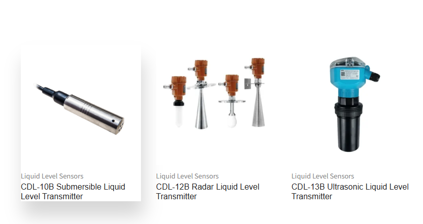
Water level sensors are essential components of any hydro-met station. They measure the depth or height of water in places like rivers, reservoirs, lakes, and even tanks. These sensors send real-time data to help monitor changing water conditions. Their key uses include:
These sensors can detect rising water levels and send early warnings. This allows communities to take action before flooding causes serious damage.
These sensors track how much water is in reservoirs or tanks. They help manage water supply for drinking, irrigation, and industry. This ensures water is used wisely and sustainably.
Changes in water levels can reveal the impact of urban development, climate change, or pollution. Water level sensors help researchers study these trends over time.
In coastal or river areas, real-time water data ensures safe movement of ships and boats, especially during storms or high tides.
Different environments require different sensor types. Common options include:
These use radio waves to measure the distance to the water surface. They are highly accurate and work well in all weather conditions.
These send sound waves to detect the water surface. They’re great for shallow water, and commonly used in rivers and irrigation channels.
These sensors sit underwater and measure the pressure created by the water above. They’re often used in deep reservoirs, dams, or lakes.
These simple mechanical devices use a floating element to show changes in water level. While older in design, they’re still useful in certain low-cost or low-tech setups.
Bringing weather and water data together provides a full picture of environmental conditions. This integration offers several benefits:
By combining rain, wind, and water level data, authorities can respond quickly to emergencies like floods or landslides.
Governments, farmers, and utility managers can make better plans based on reliable, real-time data.
The combination of data helps improve forecasts for weather events, droughts, and floods—saving time, money, and lives.
Hydro-met stations and water level sensors serve a wide range of industries:
Real-time water monitoring helps prevent disasters by sending alerts before flooding occurs.
Tracking weather and water changes over the years helps scientists see how the climate is changing. It also shows how water systems react.
Farmers use these systems to monitor rainfall and soil moisture, optimizing irrigation schedules and conserving water.
By adding temperature, turbidity, and pH sensors, these systems can track the health of lakes, rivers, and reservoirs.
In areas vulnerable to tsunamis, typhoons, or storm surges, early warning systems can save lives and reduce economic loss.
Hydrological meteorological stations and water level sensors are not just tools—they are the backbone of modern environmental management. They provide precise, live information.
This data helps us prepare for climate challenges. It also helps manage water resources. Finally, it protects both nature and people.
As we experience more extreme weather and environmental challenges, these technologies will be crucial for a safer, sustainable future.
Learn how an environmental data logger converts
Discover how ultrasonic weather stations power s
Learn how pyranometers enable accurate solar pow
Contact: Molly
Phone: +86-17775769236
Tel: 86-0731-85117089
Email: molly@codasensor.com
Add: Building S5, Aux Square, Yuelu District, Changsha City, Hunan Province, China
We chat